Dig Diary 22: A Tour of the Excavation: Part Two
March 21, 2016
Introduction
In our last post we began our overview tour of the excavation and the archaeology that we are uncovering and working on in each area of the site. For information on the Eastern, Western and Southern Extension areas please refer to Site Progress 21. This week we are discussing the central areas of the site: mainly our roundhouses and the remnants of the timber causeway.
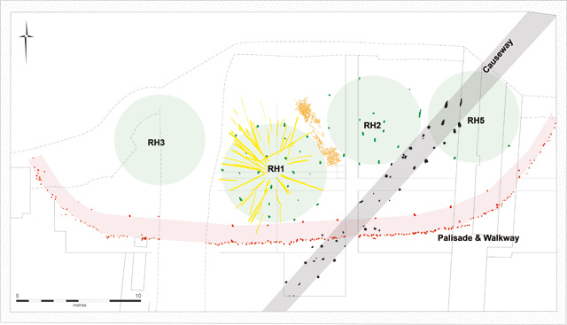
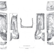
Simplified site plan showing the overall excavation. Areas marked in green are roundhouses, the palisade enclosing the settlement is marked in red and the earlier timber causeway is highlighted in grey. The dot-dash line closest to the top of the image (north) shows the edge of the quarry where more of the settlement would once have been.
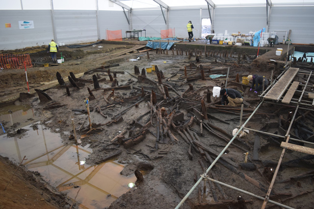
Central Western Area – “Roundhouse One” and More
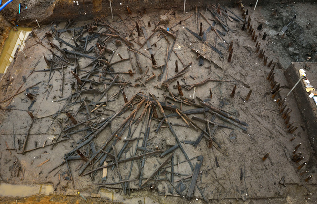
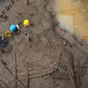
Image showing RH 1 before occupation deposits were exposed. The roof timbers seem to have retained their original position in a “fan” shape.
The most noticeable element of the central western area is the fact it’s dominated by our largest structure: roundhouse one (RH 1). This building has been fairly well discussed in previous blogs and media coverage, however now that we are investigating the occupation deposits beneath it we are getting a better understanding of the house. There are an awful lot of charred structural timbers associated with it and fairly large portions of the roof appear to survive (colour-coded yellow on the plan). Just outside the house’s footprint are areas of wattle panelling (highlighted in orange) which we are yet to examine more thoroughly. It is possible they could have formed part of the walls of the structure or, more recently, we have been considering if they could have been some form of division between different dwellings within the settlement.
We are currently working on three of the four quadrants (see RH 1 on plan for positioning) of the occupation deposit underneath the house, revealing some interesting artefacts and areas. Outside the extent of the structure are clusters of butchered animal bone and pottery fragments. These objects are all suggestive of “waste” that has been dumped outside the house into the water below. Inside the house we are finding complete vessels, very similar to those recovered from the evaluation. Wooden artefacts, such as boxes and platters have also emerged.
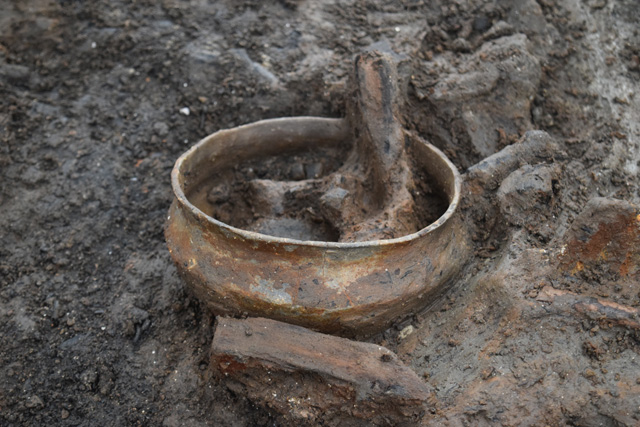
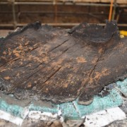
Complete pot found directly underneath the interior of RH 1. Many other complete vessels are appearing in the occupation deposit.
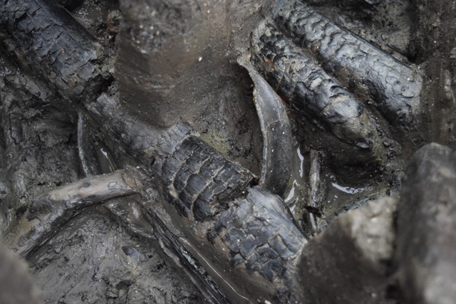
Examining this roundhouse is a complex task and the charred timbers that would have once made up its various structural elements are key to understanding the building. We are continuing to study and record the wood, some of which is unburnt, as well as examine other organic elements present which may be thatch or turf. Alongside this there is still much to expose and understand about the occupation layers, particularly trying to see if we can detect more patterning amongst artefact types.
To the north of the central western area, close to the baulk in the centre of the site, we have another structure: RH 2. However, as we remove the baulk this will become clearer and we should be able to tell which horizontal timbers belong to this house. The density of the wood makes excavation and interpretation complex and challenging, but satisfying once it all begins to tie together. This area is a focus for the project and we’ll continue to work on this area to make additional structures clearer and to reveal more about the occupation layers.
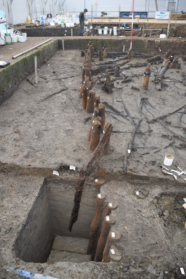
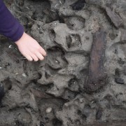
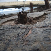
Image showing the depth of some of the palisade posts. The different coloured post slightly out of line with the main palisade is made from oak, rather than ash.
Lastly, there is also the palisade to examine (marked in red on the plan). Given the sheer number of posts that make it up, we won’t be able to excavate and record each one in full. Instead we will be doing a selective sample looking at a percentage and any that appear unusual. Most of the palisade is made of ash posts although there are occasional uprights that appear to be oak, which is particularly interesting. We currently aren’t sure why this happens and it’ll be interesting to see how the shape and length of these unusual posts differs.
The ash uprights are quite narrow in diameter, which prevents their use in dendrochronology. However, we will still be able to utilise the tree rings to gather information about the palisade and its construction. As well as studying the wood chips associated with the posts we can use the tree rings to see if the wood was grown in managed woodland. If the ring sequences are all very similar this can be an indicator of coppicing, which provides insight into land management and careful planning in Bronze Age Fenland.
Central Eastern Area – Houses and Timber Causeway Overlap
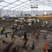
Working shot showing the Central Eastern Area. The large, dark timbers to the left of the image are posts from the causeway. In the centre of the image, to the left of the white sample buckets, you can just make out the interior post ring from RH 2.
The central eastern area is a particularly deep, dense mass of wood. Much of the wood overlaps and as we work our way through the timber, recording and removing it, even more emerges from below. It has been a tricky process which is still very much ongoing. RH 2 is primarily located in this portion of the site and its central post ring is now particularly visible. Although it is less obvious than RH 1 it seems to be a similar size but with less clear upright posts.
RH 4 is missing from the plan, as there are currently some questions over whether it is a structure or not. Within this portion of site are several areas of timbers that look structural, including a cluster that seems to be retaining a “fan” shape reminiscent of the roof of RH 1. However, until we can investigate further and examine more of the wood surrounding these groups, we are being a little cautious in identifying it more conclusively.
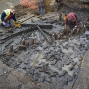
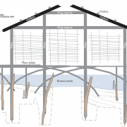
The other great aspect about this area of the site is that it demonstrates the houses here were built on stilts above the river. The large oak causeway posts that run across the course of the river channel (highlighted in grey on the plan) go straight through the outlines of the buildings, most notably RH 5. Our dating evidence for these large oak uprights shows they predated the settlement. So, if people weren’t living on raised dwellings above the water, these huge oak posts would be sticking up through the floor of their houses!
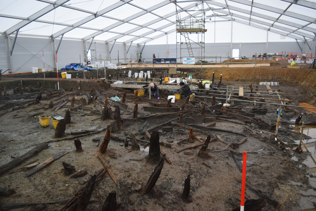
Image showing the overlap of the large causeway timbers and the smaller uprights from RH 5 in the foreground of the photo.
A key aspect of excavation in this area will be unpicking this relationship between the causeway and the structures. We know that the buildings and the timber walkway belong to different periods, so separating out their elements is important and can help us refine some of the more complex subtleties about this relationship. Was the settlement positioned near this old causeway for a particular purpose? Was the causeway still partially in use as a route through the landscape and, if so, what condition would it have been in?
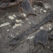
Pot with timber from the wood mass resting on top of it. This highlights the slight separation caused by the heavier objects falling to the bottom of the river whilst more buoyant material floated before sinking.
We are already seeing pots and wooden bowls just starting to appear from the silt as we carefully examine the timbers in this section of the site. The next stages in the central eastern area are to continue the wood recording and removal while trying to understand the extent and character of the houses in this portion of the settlement.
Must Farm – More Questions to Answer
Whilst this overview of the site and its components is not the same as a physical tour of the project, hopefully it has helped to give a summary of the archaeology we are working on. We have been working extremely hard over the past months to excavate and interpret this fantastic Bronze Age archaeology. We still have many questions to try and answer, in each area of the site and for the settlement as a whole. However, the condition and quality of the archaeology that we are encountering suggest that we’ll be able to find answers and help to further understanding of Fenland, and more general Bronze Age, prehistory.
Related stories
Dig Diary 25: Wooden Objects
April 11, 2016
Dig Diary 24: Visualising the Site
April 4, 2016
Dig Diary 23: Footprints and Posts
March 28, 2016
Dig Diary 22: A Tour of the Excavation: Part Two
March 21, 2016
Dig Diary 21: A Tour of the Excavation: Part One
March 14, 2016
Dig Diary 20: Excavating in the Fenland Landscape
March 7, 2016
Dig Diary 19: Discovering Britain’s Oldest, Complete Wheel
February 29, 2016
Dig Diary 18: Looking Inside and Outside Roundhouse One
February 22, 2016
Learn more
About
Publications
Post-Ex Diaries
Our work on-site has finished but lots more investigation is taking place as we study both the material and the evidence we recovered. ...read more
Discoveries
See some of the discoveries from the Must Farm pile-dwelling settlement.
Making Must Farm
Find out about our work with AncientCraft recreating Must Farm’s material.
FAQs
Further information on the Must Farm project.