Dig Diary 24: Visualising the Site
April 4, 2016
Recording Techniques
Excavating such a dense and complex site requires the use of a variety of means to record and visualise the archaeology. Before we began the project we knew we would need a calculated strategy to be able to deal with the large quantities of timbers and artefacts. We would have to quickly plan and process the archaeology alongside being able to record it effectively, in a visual way.
Our strategy revolved around the use of a combination of record photography, illustration and photogrammetry. Once we began to uncover the site it became clear that there was more archaeology than we could ever have expected. Thankfully, combining techniques has allowed us to deal with this increased density while simultaneously providing some fantastic results.
Photography
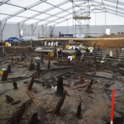
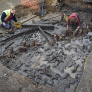
Photography is an incredibly valuable technique that allows us to record and highlight a range of different archaeological features and objects. We are fortunate enough to have a very talented and experienced photographer, Dave Webb, working on the project. His images are extremely useful at capturing the completeness of the settlement, which helps us to separate out different elements of the archaeology.
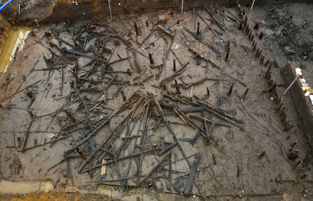
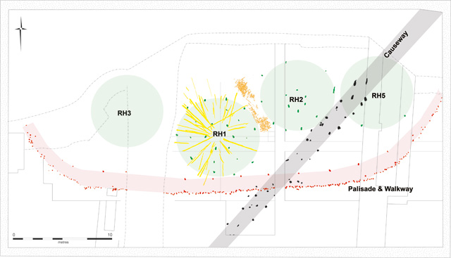
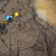
Overhead photograph showing Roundhouse 1. These amazing shots give us the ability to understand and target archaeology as we are working on it.
Using boom photography lets us get a more comprehensive, overhead perspective on the timbers and wood mass in particular. This viewpoint allows us to help separate the uprights into groups and spot the emerging shapes of the stilted roundhouses. The overhead shot taken of roundhouse one gave us a fantastic outline of the structure, very clearly separating out each ring of posts. Having this ability allows us to plan excavation strategies much more efficiently which is so important with such a large amount of timber to examine and remove.
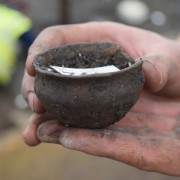
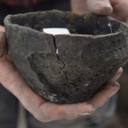
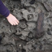
Record photography is equally essential to the excavation, giving us high-quality and detailed images of important areas and artefacts. Photographs can help to highlight interesting elements of objects, such as tool marks on wooden objects or use wear on ceramic vessels. With such a large quantity of structural timbers being removed, having a comprehensive record of the different elements of the building will be of particular use during the post-excavation analysis of the houses. At the other end of the size spectrum having detailed photographs of the smallest objects, such as beads, is also important for the artefact record.
Photogrammetry
Photogrammetry is a slightly different technique that uses photographs to create measurements between objects and 3D models. There are relatively strong ties between photogrammetry and survey and the technique forms the basis of planning the archaeology on site. The first stage involves taking several hundred photographs from different angles and elevations, using a standard digital SLR camera, of a cleaned area of site. These images are then examined and any unwanted elements removed: such as scaffolding, tripod legs, feet and so on. This process is known as “masking” and leaves us with a set of a few hundred images purely of the archaeology.
The images are then uploaded into a piece of software, Agisoft Photoscan, which combines the photos using overlapping pixels. Owing to the number of photos taken and the overlap created between them, the software is able to work out where they were taken and create a low-density point cloud: effectively a simplified 3D model. This is then located onto an Ordnance Survey grid, by including target points that have been placed using a total station. Once this has been done, a more detailed dense point cloud is created which is accurate to 7mm within the confines of control points.
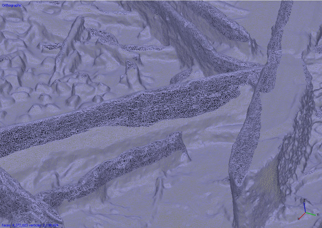
Screenshot of mesh image stage of the photogrammetry process. These are horizontal timbers from the wood mass deposit.
The dense point cloud is then transformed into a mesh, by joining up approximately one third of the points in the cloud. Once the mesh is complete it is textured: a process which gives the model its detail. This is then exported and becomes a fully manipulable 3D model accurate to a sub-centimetre scale. On top of this each find and piece of wood has its metadata attached to it which allows for the use of GIS in the future.
It sounds like a complex process but our surveyor, Donald Horne, has refined the process allowing for a quick turnaround of models. The models are then used as the basis for the creation of site plans, that can be produced very quickly at any scale required. Using AutoCAD to trace round the pieces of wood creates detailed scale plans that are used on site to number, record and remove wood and artefacts. The process is much, much faster than the alternative of hand planning which would be an incredibly time-consuming job for any archaeologist given the sheer quantity of wood we have on site.
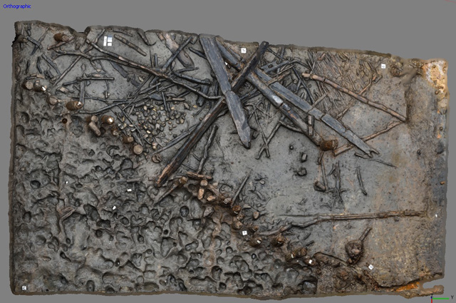
Screenshot of the vertical view of the Eastern area of site. Palisade, wood mass and exterior footprints visible in image.
We have been asked why we aren’t using another 3D modelling technique: laser scanning. This technique is expensive, costing large amounts for only short-term hiring of the equipment. Photogrammetry is a much cheaper technique, requiring a good quality SLR camera and a computer capable of processing the data. Our entire photogrammetry set-up cost the same as hiring a laser scanner for just over a week. Given the constantly changing nature of our excavation, photogrammetry is much more efficient and effective.
A further benefit of photogrammetry is that it doesn’t use a fixed resolution, unlike laser scanning. If we wish to get closer to an object and do more detailed work, for example on a delicate or small object, photogrammetry allows that. Laser scanning has mixed results on dark and wet surfaces, which is far from ideal given the waterlogged preservation of our very dark timbers. We are extremely pleased with the quality and resolution of the models we are producing from photogrammetry. The speed and the technique’s use for creating up-to-date plans, quickly, is helping to keep the project running smoothly even when faced with extremely dense archaeology.
Illustration
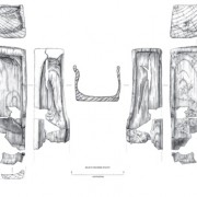
Archaeological illustration is another crucial means of visualising the archaeology we are revealing. This is a skill that requires extensive experience and understanding of both archaeology and artefacts. While one of the main aspects of illustration is producing scale drawings of artefacts, it is much more complicated than simply creating a nice image. Archaeological drawings need to highlight elements that might not be clear in a photograph or obvious on an initial inspection.
Our illustrator, Vicki Herring, has to examine objects carefully and get a sense of how they were worked and created. There is a layer of interpretation and understanding present in scale drawings that people often don’t realise. Given some of the subtle qualities of the timbers we are removing and the fine workmanship on many of the wooden objects, this is not an easy task!
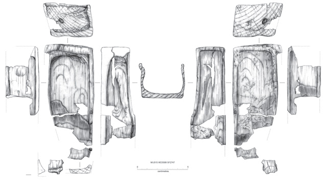
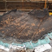
Scale drawing of the wooden box. Interpretation highlights the important elements of the object.
Much of the timber in the settlement, especially structural pieces, has been heavily charred: either partially or more fully. While this has led to the preservation of the wood, by removing its organic component, it has also left a lot of it incredibly fragile. In particular mortise joints have been badly damaged by the fire, often leaving the wood only a few millimetres thick. Excavating these incredibly delicate pieces of timber without them breaking is often impossible. However, we can ensure none of the valuable information is lost by producing scale drawings while they are still in situ, recording the markings and charring patterns as a precaution.
Illustration also works in combination with photogrammetry. The scale plans produced using AutoCAD are also refined in Illustrator to produce publication-quality graphics and images. Similarly, record photographs can be tweaked and edited to colour-code areas or emphasise particular areas or posts. Finally, illustration plays an important role in the creation and development of reconstructions. Having a member of the site team drawing these recreations is essential as this means the drawing can adapt and evolve with changing developments as they happen in the field.
Simplified site plan produced from photogrammetry model after being imported and interpreted in Illustrator.
Visualising Archaeology
Being able to visualise the site as we excavate is a critical element to working effectively. Using this combination of different techniques allows for us to continually develop a more complete understanding of the settlement as we work on the archaeology. Being able to see what we are doing, at a variety of different levels is such a valuable resource for everyone involved in the project. This could be via a detailed, overhead image of the site, a scale drawing of a beautifully worked artefact or a manipulable 3D model. All have a huge role in the project and help us to tackle this fantastic archaeology with a much broader idea of the whole settlement.
Related stories
Dig Diary 27: Pottery
April 25, 2016
Dig Diary 26: Exploring Inside a Bronze Age Home
April 18, 2016
Dig Diary 25: Wooden Objects
April 11, 2016
Dig Diary 24: Visualising the Site
April 4, 2016
Dig Diary 23: Footprints and Posts
March 28, 2016
Dig Diary 22: A Tour of the Excavation: Part Two
March 21, 2016
Dig Diary 21: A Tour of the Excavation: Part One
March 14, 2016
Dig Diary 20: Excavating in the Fenland Landscape
March 7, 2016
Learn more
About
Publications
Post-Ex Diaries
Our work on-site has finished but lots more investigation is taking place as we study both the material and the evidence we recovered. ...read more
Discoveries
See some of the discoveries from the Must Farm pile-dwelling settlement.
Making Must Farm
Find out about our work with AncientCraft recreating Must Farm’s material.
FAQs
Further information on the Must Farm project.