Dig Diary 14: Excavating our Structures
January 25, 2016
Recording and removing our roof
Exposing and cleaning the burnt wood mass was an important, and very useful, strategy for us. Excavating the site in this way meant that revealing the wooden debris and uprights simultaneously allowed us to easily identify the round houses. This has allowed us to develop and tailor strategies for recording and digging these structures that will help us to maximise the information that we can gain from them.
We have had a little more time to examine the buildings and their architecture is very consistent with what we know about later Bronze Age structures. This type of house is as culturally diagnostic as pottery or metalwork. It is a style of building common to the period, reminiscent of the posthole houses we find on dry ground. Our first structure has a diameter of approximately 8m which is very similar to a series of buildings with slightly later dates excavated locally during the 1990s. However, most round houses of these periods rarely contain much evidence about their interiors.
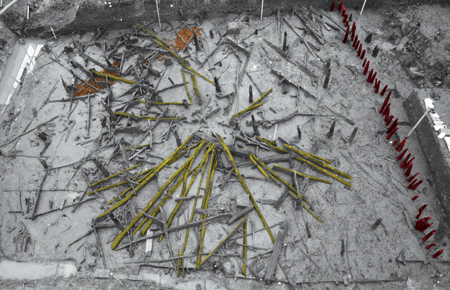
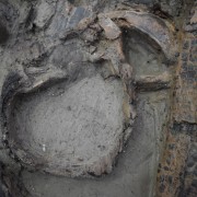
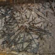
Image highlighting the Bronze Age roof in situ
At Must Farm we currently have the amazing remnants of a Bronze Age round house roof, which has led to great excitement. This roof is sitting on top of, and currently sealing, all of the remains of the building’s interior. These remains are most likely a source of lots of new information about homes during this period of prehistory. In order to access this important series of deposits, it is necessary to remove the roof timbers, but not before they are recorded in great detail using a variety of techniques.
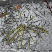
Once the roof of the round house had been exposed and cleaned we took a series of detailed, record photographs from a number of angles. This standard technique was not only a useful documentary record but helped to highlight various aspects of the roof we were keen to highlight, such as the position of the fallen radial timbers. We then used photogrammetry across the entire area to be able to produce a manipulable 3D model alongside a scale plan of the entire area of the collapsed roof. This plan was a very useful resource that helps us coordinate the more detailed recording of the timbers.
Recording and removing roof elements
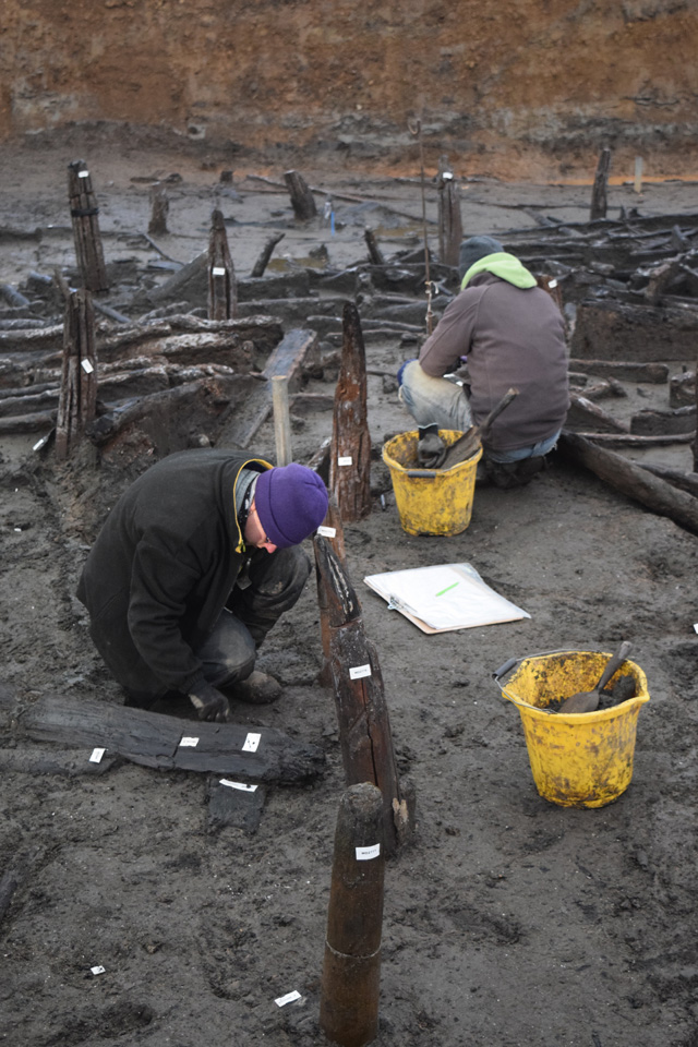
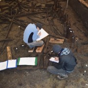
Rather than simply remove the entire roof remains, we opted for a tried-and-tested archaeological strategy: dividing the round house into quadrants. Doing so allows us to leave much of the roof in place while we begin to excavate a small portion of the deposits lying underneath. It also creates two sections, allowing us to see the interior remains in profile: a useful way to see the stratigraphy of these layers clearly. Once our first quadrant has been excavated we will have a much better understanding of the structure as a whole, allowing us more insight as we then progress onto the other areas.
We’re currently in the process of removing the roof in our first quadrant and it is proving to be a complicated task. Each timber is recorded in detail using the same system we discussed in an earlier blog entry. As these are structural timbers, additional information is also recorded such as their potential groupings (such as rafters). If the timber looks particularly fragile or has some unusual evidence of working, it is drawn in situ. Drawing is essential as it allows our illustrator to create a measured, detailed representation of the wood that highlights elements that are not clear in photographs or photogrammetry. Only when each and every timber and fragment of wood has been recorded will we begin to excavate.
Scientific Analyses and Environmental Sampling
Underneath the roof remnants we are expecting to find the interior contents of the round house. While this obviously includes the exciting finds associated with the dwelling – pots, querns, metalwork and textiles – there is also another important element to excavating this material. The wealth of modern scientific techniques available to us are critical in understanding the formation of the site alongside how it would have been used.
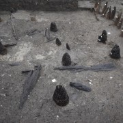
As we discussed recently our working theory of the site is that it comprised a series of stilted round houses situated next to an earlier, wooden causeway similar to Flag Fen. We have a large number of oak uprights and a wealth of burnt, structural timbers. So, how do we go about proving that these houses were raised up on stilts? One way we can do this is to use a range of environmental analyses to examine differences in the sediments underneath and outside the buildings.
In round houses built on terrestrial ground, their interiors can have very different and distinct environmental signatures from the land outside them. However, in our dwellings, built over a river, there will only be slight and subtle changes in the sediments on the bottom of the channel directly underneath the houses. In order to get these results we need to examine evidence from creatures and plants that are very sensitive to changes in environment, such as algae and insect larvae. If we can see the same tiny creatures and plant signatures in samples from both outside and inside the buildings, we can be fairly sure that there was a river running underneath raised buildings.
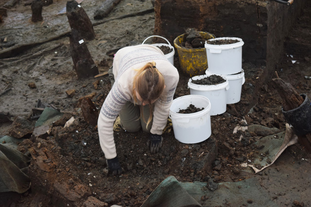
Sampling for environmental analyses
Using miniscule, microscopic animals and plants can help us to answer some of the biggest questions, including how our structures could have appeared. This is only one scientific technique, being applied in just one way. Throughout our entire excavation we are lucky enough to be working with a very wide range of specialists who bring expert knowledge that can help us in so many different ways. We have specialists looking at pollen, spores, microfossils, mosses, phytoliths, insects, lipids and a huge range of geoarchaeological analyses to name just a few.
This type of specialist, fine-grained analyses are absolutely crucial in being able to understand the site as a whole entity. Using these techniques in conjunction with our standard excavation practices is extremely important. Having experienced, trained specialists who can bring their own unique knowledge to the project is helping us get as much information and understanding about the settlement here.
When we have been discussing the occupation deposits, associated with the houses here, people seldom consider that they will be anything other than piles of artefacts with silt in between them. However, the environmental data these layers hold is just as valuable to us as metalwork or textiles. Ensuring we are recording and sampling these deposits, and having the experts to examine them, is critical to building up a truly complete picture of the site.
Related stories
Dig Diary 17: Formality and the Must Farm Settlement
February 15, 2016
Dig Diary 16: Earlier and Later Periods in the Fenland Basin
February 8, 2016
Dig Diary 15: Exploring the Occupation Deposit
February 1, 2016
Dig Diary 14: Excavating our Structures
January 25, 2016
Dig Diary 13: Exploring Our Earlier Oak Post Alignment
January 18, 2016
Dig Diary 12: Discovering Our First House
January 11, 2016
Dig Diary 11: The Importance of the Wood Record
January 4, 2016
Dig Diary 10: Looking Further Afield
December 21, 2015
Learn more
About
Publications
Post-Ex Diaries
Our work on-site has finished but lots more investigation is taking place as we study both the material and the evidence we recovered. ...read more
Discoveries
See some of the discoveries from the Must Farm pile-dwelling settlement.
Making Must Farm
Find out about our work with AncientCraft recreating Must Farm’s material.
FAQs
Further information on the Must Farm project.